Geological aspects
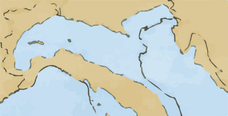
Northern Italy in the Pliocene: the bold continuous line shows Italy’s current contour, the finer line shows the coastline in the Pliocene; the current territory of the Po Valley was submerged during this era, forming a huge gulf in the Adriatic Sea.
The formation of the Po-Veneto Plain, along with the entire Italian Peninsula, has been conditioned by the intense Alpine orogenic activity that took place between the Cretaceous (130 million years ago) and the Pliocene (2 million years ago).
At the end of the Pliocene the wide gulf that runs between the Alps and the Tuscan-Emilian Apennines was completely submerged by the sea which touched the Piedmontese Alps. Between the Pliocene and the Early Pleistocene this inlet was progressively filled by marine (particularly on the eastern slide) and fluvial deposits.
The sea level was almost 100 meters lower than current level and the plain was at the current level of the city of Ancona. The rivers of Veneto were tributaries of the river Po while now they flow directly into the Adriatic “separating” the Veneto Plain from that of the Po. At the beginning of the post glacial period at around 10-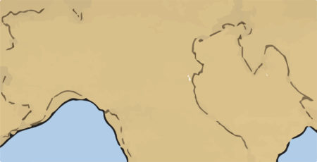
 The upper plain has a fairly steep inclination (15%) as the rivers, as a result of the high rates of water dispersion into subsoil, rapidly lose their flow rate depositing the major part of the coarser gravel material. This is, in fact, the recharge area for the aquifers. In this type of highly permeable terrain, the groundwater, which has horizontal flow speeds of up to 12 meters a day, makes up an aquifer in which the isophretic (lines which connect the points of equal depth of the aquifer) are close together, proceeding towards South-East at the altitude of the land surface. On the lower plain the gradient of the incline decreases (2%), the fine materials deposited have poor permeability and separate a series of aquifers whose waters flow at the speeds between 1-10 centimetres per day.
These aquifers are often under pressure and may supply artesian wells where the waters are pushed up to a height that balances the level of their supply point, as demonstrated by the principles of communicating vessels. The area of transition between the upper and lower plain is defined by some authors as the “middle valley”, this is the area of the resurgence belt, where we have spontaneous surfacing of the aquifer. The underground aquifer, is in fact, largely supplied by rainwater and river water that penetrates the permeable land of the upper plain to the north, it has a notable hydrostatic load, but its flow is prevented towards the South by the impermeable terrain of the lower plain.
In this way the waters are “forced” to emerge forming the resurgences. From a purely hydraulic point of view the resurgences represent an “over fill” of the large unconfined aquifer in the Vicenza area..
The upper plain has a fairly steep inclination (15%) as the rivers, as a result of the high rates of water dispersion into subsoil, rapidly lose their flow rate depositing the major part of the coarser gravel material. This is, in fact, the recharge area for the aquifers. In this type of highly permeable terrain, the groundwater, which has horizontal flow speeds of up to 12 meters a day, makes up an aquifer in which the isophretic (lines which connect the points of equal depth of the aquifer) are close together, proceeding towards South-East at the altitude of the land surface. On the lower plain the gradient of the incline decreases (2%), the fine materials deposited have poor permeability and separate a series of aquifers whose waters flow at the speeds between 1-10 centimetres per day.
These aquifers are often under pressure and may supply artesian wells where the waters are pushed up to a height that balances the level of their supply point, as demonstrated by the principles of communicating vessels. The area of transition between the upper and lower plain is defined by some authors as the “middle valley”, this is the area of the resurgence belt, where we have spontaneous surfacing of the aquifer. The underground aquifer, is in fact, largely supplied by rainwater and river water that penetrates the permeable land of the upper plain to the north, it has a notable hydrostatic load, but its flow is prevented towards the South by the impermeable terrain of the lower plain.
In this way the waters are “forced” to emerge forming the resurgences. From a purely hydraulic point of view the resurgences represent an “over fill” of the large unconfined aquifer in the Vicenza area..
At the end of the Pliocene the wide gulf that runs between the Alps and the Tuscan-Emilian Apennines was completely submerged by the sea which touched the Piedmontese Alps. Between the Pliocene and the Early Pleistocene this inlet was progressively filled by marine (particularly on the eastern slide) and fluvial deposits.
The glaciations
The present day appearance of the Po-Veneto Plain is the result of glacier movement during the four phases of the quaternary glaciations (GÜNZ, MINDEL, RISS and WÜRM) and the relative interglacial phases (from 100,000 to 10,000 years ago). The glaciers that covered the Alpine valleys, often at depths of up to 2,000 meters, caused major erosion and the resulting residues accumulated to form amphitheatre shaped moraines on the plain at the foot of the valleys. During the interglacial periods this material was washed away by the rivers and redeposited on the plains sorted by size: the coarser gravel first, followed by the sand and lastly the lime and clay deposits. The maximum advancement during the WÜRMIANA period came at around 30/40 thousand years ago with moraine deposits almost completely covering all those from previous eras.The sea level was almost 100 meters lower than current level and the plain was at the current level of the city of Ancona. The rivers of Veneto were tributaries of the river Po while now they flow directly into the Adriatic “separating” the Veneto Plain from that of the Po. At the beginning of the post glacial period at around 10-
Northern Italy in the Würmiana glacial era of the Pleistocene: the bold outline marks the coastline in the Würmiana period; the level of the sea was notably lower because of the enormous mass of water that was contained in the continental glaciers.
15 thousand years ago, the rivers started to form the current layout of the valley and create the conditions for the formation of resurgences (risorgive). Rivers progressively lose their transport capacity while approaching the plain.
The material washed out from the morainic deposits of mixed grain size are generally, but not always, deposited in order (gravel-sand-lime-clay) depending on varying factors, such the periodic flows of flood-water and the lithologic composition (different weight of the rocks). Furthermore, in the past, rivers without embankments frequently changed their bed, causing deposits from different rivers to layer over each other.
The result of the glaciations
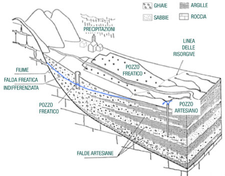
The result of the actions described is an alluvial layer that when studied in cross section, displays layers of gravel alternated with sand, at times be compacted, and with clay that confines aquifers of greater or lesser pressure. Analysing a section of the Veneto Plain from the North-West to the South-East, we see that the gravel dominates towards the North (the upper plain) while the finer sediment is more prevalent towards the South (the lower plain). Between the different levels of the plain there is a transition area (middle valley), with mixed lithologic features, which in the Vicenza area extends in breadth from 2 to 10 kilometres and at sea level is between 64 and 30 metres.
The upper plain has a fairly steep inclination (15%) as the rivers, as a result of the high rates of water dispersion into subsoil, rapidly lose their flow rate depositing the major part of the coarser gravel material. This is, in fact, the recharge area for the aquifers. In this type of highly permeable terrain, the groundwater, which has horizontal flow speeds of up to 12 meters a day, makes up an aquifer in which the isophretic (lines which connect the points of equal depth of the aquifer) are close together, proceeding towards South-East at the altitude of the land surface. On the lower plain the gradient of the incline decreases (2%), the fine materials deposited have poor permeability and separate a series of aquifers whose waters flow at the speeds between 1-10 centimetres per day.
These aquifers are often under pressure and may supply artesian wells where the waters are pushed up to a height that balances the level of their supply point, as demonstrated by the principles of communicating vessels. The area of transition between the upper and lower plain is defined by some authors as the “middle valley”, this is the area of the resurgence belt, where we have spontaneous surfacing of the aquifer. The underground aquifer, is in fact, largely supplied by rainwater and river water that penetrates the permeable land of the upper plain to the north, it has a notable hydrostatic load, but its flow is prevented towards the South by the impermeable terrain of the lower plain.
In this way the waters are “forced” to emerge forming the resurgences. From a purely hydraulic point of view the resurgences represent an “over fill” of the large unconfined aquifer in the Vicenza area..